Here’s 10 ways Sedgwick County’s political boundaries could be redrawn
READ MORE
Changing Sedgwick County’s district boundaries
Sedgwick County is about to redraw the five commission districts in the county. So far, there are 10 proposed redistricting maps that the public can weigh in on Monday before the County Commission decides who will represent whom.
Expand All
Once a decade, the Sedgwick County Commission redraws its five district boundaries so that each commissioner represents roughly the same number of people.
The new district lines could decide the political future of county government, which makes key decisions about public health, disaster response, emergency medicine, the county jail, mental health and disability services.
The target population for each district this year, based on 2020 Census data, is 104,765 people, or 20% of the county’s total population of 523,824.
Districts 1, 3 and 5 are within 1% of the target population. But District 2, generally south-central Sedgwick County, has a population of 99,804, and District 4, primarily north Sedgwick County, has 109,341 people.
The maps below show the county districts as they exist today and 10 proposed plans under consideration by the Sedgwick County Commission.
The public will get the opportunity to comment on the proposals at a town hall meeting at 6:30 p.m. Monday in the lecture hall at the National Center for Aviation Training, 4004 N. Webb Road.
The Wichita Eagle gathered and analyzed data on race, ethnicity and voter registration demographics and calculated the potential implications the plans could have on political and racial voting power.
The white lines on the maps represent the existing district boundaries, which were approved in 2011. The shaded areas on the maps show the proposed district boundaries under each plan.
Below each map is a general description of the proposed changes and a data table showing the political shifts, based on voter registration numbers.
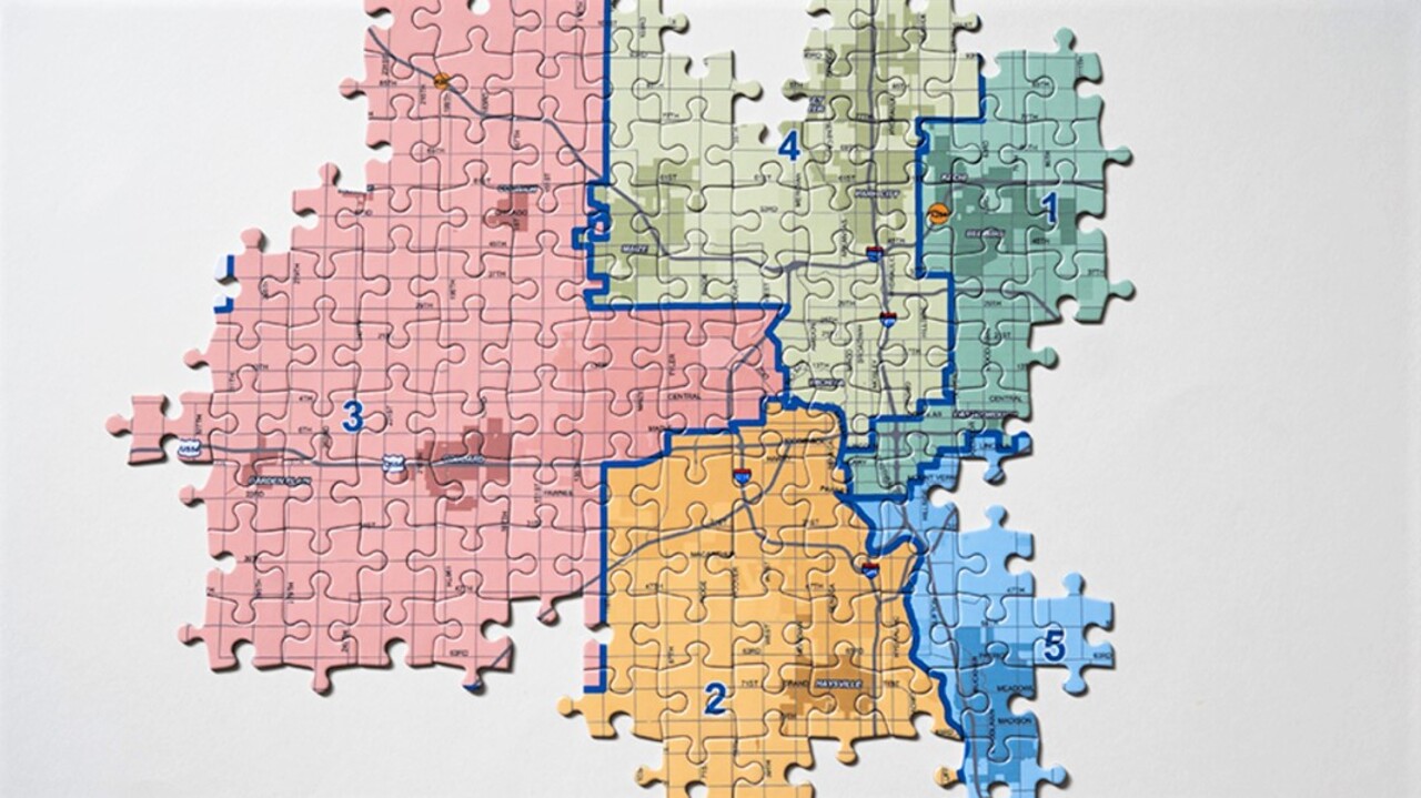
Current Sedgwick County Commission map
Here is the current map of districts for the Sedgwick County Commission.
District 1: Pete Meitzner, a Republican, won by 2,162 votes in 2018.
District 2: Sarah Lopez, a Democrat, won by 264 votes in 2020.
District 3: David Dennis, a Republican, won by 15,620 votes in 2020.
District 4: Lacey Cruse, a Democrat, won by 3,534 votes in 2018.
District 5: Jim Howell, a Republican, won by 3,142 votes in 2018.
Race: Black residents are split across all of the districts and do not represent more than 13% of the population in any district. Black residents make up 9% of the Sedgwick County population; 84% of Black residents are concentrated in commission Districts 1, 4 and 5. Black and Hispanic voting power is concentrated in District 4, where Black residents make up 13% of the population and Hispanic or Latino residents represent 24% of the population. Racial and ethnic minorities have the least voting power in District 3, where 79% of the population is white, 2% is Black and 10% is Hispanic.
Politics: All districts are majority Republican.
Plan 1

What would change?
Under Plan 1, 59 voting precincts would change districts. Some of the major changes include:
▪ Maize would move from District 4 to District 3
▪ Delano would move from District 3 to District 4
▪ Orchard Park neighborhood would move from District 3 to District 4
▪ Mead and Longview neighborhoods in southeast Wichita would move from District 1 to District 5
▪ Wichita State University and Koch Industries would move from District 4 to District 1
▪ Heights High School and Stucky Middle School plus nearby neighborhoods would move from District 1 to District 4
Race: Half of District 4’s Black residents would be drawn into other districts. This map would place 40% of Sedgwick County’s Black residents in District 1, increasing the district’s Black population from 12% to 17%.
Black voters would lose power in District 4, where they would drop from 13% to 7% of the total district population.
Politics: Republicans would hold a majority in each district. Democratic voters would gain power in Districts 1, 2 and 5. Republicans would gain power in Districts 3 and 4.

Plan 2
What would change?
Plan 2 would require slight adjustments in all of the Sedgwick County Commission districts.
All of downtown Wichita between Douglas and Kellogg east of the Arkansas River to Washington would move from District 4 to District 1. The area includes Century II, Intrust Bank Arena and Naftzger Park.
Wichita State University and Koch Industries would shift from District 4 to District 1.
The Mead neighborhood, which is now divided between Districts 1 and 5, would move into District 5.
Race: No major changes.
Politics: Republicans would hold a majority in each district. Democratic voters would gain power in Districts 1, 2 and 5. Republicans would gain power in Districts 3 and 4.
Plan 3
What would change?
Plan 3 keeps all existing district boundaries in place, with the exception of the Riverside and Indian Hills neighborhoods, which would shift from District 4 to District 2.
Race: No major changes.
Politics: This map would be the simplest adjustment but would have major political implications for Democrats Lacey Cruse, who received 1,234 votes in those neighborhoods in 2018, and Sarah Lopez, who stands to gain Democratic voters after narrowly defeating Republican Michael O’Donnell in 2020. Republicans would retain a majority in each district, increasing power in District 4.
Plan 4
What would change?
Plan 4 is nearly identical to Plan 3, with Riverside and Indian Hills shifting from District 4 to District 2. This plan also straightens a jagged district boundary at 119th Street between Maize and Colwich, a move that shifts a handful of mostly Republican voters from District 4 to District 3.
Race: No major changes.
Politics: Like Plan 3, this map would increase Democratic voters in District 2 at the expense of District 4. Republicans would retain a majority in each district.

Plan 5
Plan 5 redraws most of the district boundaries in Sedgwick County. Districts 2 and 4 would lose considerable land mass but together would represent most of the core of Wichita’s population. An area with the highest concentration of racial minorities and some of the highest poverty rates in the county, near I-135 from 21st Street to Douglas, would move from District 4 to District 1. District 1 would also include some of the highest income neighborhoods in the county and would add Valley Center and Park City. District 3 would grow considerably, absorbing the cities of Maize and Clearwater. District 5 would grow, adding south Haysville and east Wichita neighborhoods surrounding the Wichita Country Club and the Crestview Country Club.
Race: This map would place 44% of Sedgwick County’s Black population in District 1, and the district would expand its reach to the largely white suburban cities of Valley Center, Park City and Bel Aire. It also would nearly double the number of Black residents in District 2. The Black population in District 4 would drop from 13% to 5%.
Politics: Republicans would keep majorities in each district, increasing voting power in Districts 3, 4 and 5. Democratic voters would gain power in Districts 1 and 2.

Plan 6
What would change?
The neighborhoods around Heights High and Stucky Middle schools and suburban Bel Aire would move from District 1 to District 4.
Neighborhoods around Wesley Hospital and MacDonald Golf Course would move from District 1 to District 4. District 1 would pick up the area south of Douglas to Harry east of the Arkansas River, including Century II, Intrust Bank Arena and Naftzger Park, which are now in District 4.
District 2 would pick up the South Central neighborhood south of Harry near Broadway.
Race: No major changes.
Politics: Each district’s voting composition would remain largely unchanged, with Republicans keeping a majority in each district. The biggest swing would be in District 4, where Lacey Cruse would lose 938 Democratic voters and 656 Republican voters.

Plan 7
What would change?
Much like Plans 3 and 4, Plan 7 would shift Riverside and Indian Hills to District 2.
District 4 would gain the Heights High and Stucky Middle schools neighborhoods and the Hyde Park neighborhood south of Douglas to Kellogg from Washington to Hydraulic.
Race: No major changes.
Politics: Again, the biggest change would come in District 4, with a 322-voter swing in favor of Republicans. Democratic candidates in District 2 would benefit from the addition of Riverside.

Plan 8
What would change?
The Indian Hills neighborhood would move from District 4 to District 2.
The Hyde Park neighborhood, East High and East Front neighborhood would move from District 1 to District 4. District 3 would also add newer housing development and agricultural land northwest of Wichita.
Race: No major changes.
Politics: Republicans would see small gains in Districts 1, 2 and 3. District 4 would lose voters from both parties but would shed 517 more Republican voters than Democratic voters.

Plan 9
What would change?
Plan 9, proposed by Commissioner Lacey Cruse, would allow her to keep Riverside in her District 4 while shifting voters to Commissioner Sarah Lopez’s District 2 from both District 4 and Commissioner Pete Meitzner’s District 1.
Sunnyvale in far north Sedgwick County would move from District 4 to District 1.
Two precincts on the east bank of the Arkansas River between Douglas and Lincoln would move from District 4 to District 2, as would a single precinct south of Central between Clayton and Meridian.
One precinct, just east of the river between Lincoln and Harry, would move from District 1 to District 2.
Race: Data not available
Politics: Meitzner, a Republican, would shed a Democrat-majority south Wichita precinct to Lopez and pick up a much larger Republican-dominated precinct in the north county from Cruse.
Lopez, a Democrat, would pick up a few registered Democrats from Meitzner and Cruse. Cruse, also a Democrat, gives some Democrats to Lopez but more than makes up for it by shifting Republicans to Meitzner.

Plan 10
What would change?
This map, proposed by Commissioner Jim Howell, would divide up District 3, now represented by Commissioner David Dennis, which Howell thinks is too large and rural.
The town of Bentley and neighboring areas would move from District 3 to Lacey Cruse’s District 4. Voters in an area along North Ridge Road would be moved from District 4 to District 3.
Commissioner Sarah Lopez’s District 2 would pick up a large area of the rural southwest county, including the city of Viola.
Race: Data not available
Politics: Lopez, a Democrat, won a squeaker last year against scandal-plagued opponent Michael O’Donnell, who had already announced he would resign if elected. The precincts Howell would add to that district are all deep-red Republican, which would jeopardize any chance of a Democrat being elected again in District 2.

Note: Political data tables were added for Plans 9 and 10 at 5:30 p.m., Monday.
This story was originally published November 14, 2021 at 5:05 AM.